The official photoblog of Banjo Jones & The Brazosport (TX) News

2.28.2005

Brazoria County, TX


Heading east on Farm to Market 2004. Posted by Hello

The mouth of Chocolate Bayou. Posted by Hello

Chocolate Bayou, looking south, from the Farm to Market 2004 bridge. Posted by Hello

2.25.2005

Oyster Creek, TX


The local water tower tells travelers they are in Oyster Creek, one of the smaller entities that make up the mighty Brazosport area. Posted by Hello

The Village of Oyster Creek gets its name from this body of water, which, oddly enough, is named Oyster Creek.  Posted by Hello

Don't bring your horse to the park. Posted by Hello

The local park in Oyster Creek is under surveillance! Posted by Hello

Oyster Creek has a significant industrial presence. Posted by Hello

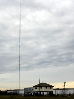
Brazosport's only radio station, KBRZ-AM, is located in Oyster Creek. For years it was a country-western station, but about 4-5 years ago it was sold for $700,000 to Aleyua Broadcasting, which changed its programming to a Spanish language religous format.  Posted by Hello

Surfside Beach, TX


Hurricanes, tropical storms and just the normal everyday processes of the Gulf of Mexico have wreaked considerable erosion on Texas beaches. The owner of the blue house built a bulkhead to keep the water from undermining his beach house. It's probably illegal, since it's technically on the public right-of-way, but I don't know the details of how he got the permit.  Posted by Hello

Can I get a witness? Not today.  Posted by Hello

Under the Texas Open Beaches law, all of this is the "public beach" even though a private home is still sitting there. This beach is supposedly going to be the site of a renourishment project to stem erosion.  Posted by Hello

Beach erosion, a never-ending problem. Galveston usually gets all the mainstream media coverage after storms remove large swaths of beach, mainly because the beach homes are nicer and more expensive than the blue-collar beach dwellings that preodominate in Surfside.  Posted by Hello

Dow Chemical in Freeport, as seen from Surfside. Posted by Hello

The so-called "Pedestrian Beach" of Surfside. Posted by Hello

I don't know the story behind this place, just thought it looked interesting.  Posted by Hello

The fishing pier. It's longer and nice than the one across the channel in Quintana.  Posted by Hello

2.24.2005

The Southwest Trail Ride


The trail ride continues Thursday on its way to the Houston Live Stock Show and Rodeo. Everyone will parade through downtown Houston on Saturday. Posted by Hello

A Lone Star of Texas motif adorns this rig. Posted by Hello

The Triple B Riders came over from the Texas City-LaMarque area in Galveston County. Posted by Hello

Most of the participants on the Southwest Trial Ride are African American. There is a strong tradition in and around Rosharon for the black man's Western heritage.  Posted by Hello

Most of the wagons are pulled by mules, but I don't think this one is.  Posted by Hello

A rolling homage to Yosemite Sam.  Posted by Hello

"My heart's calculatin', my true love will be waitin', be waiting at the end of my ride...".  Posted by Hello

A few minutes earlier, this trail rider was on a cell phone, which sort of broke the cowboy mood, but once he mounted up to move out, everyone was back in rodeo mode. Posted by Hello

2.23.2005

The Southwest Trail Ride


It's important to have a lotta flags, especially Texas flags, during the trail ride. Trail riders from other parts of the greater Houston area also were headed toward Houston on Wednesday. Here, the Southwest Trail riders were moving through Juliff in Fort Bend County. Passing motorists were cooperative and some folks came out of their homes to watch the passing parade.  Posted by Hello

The riders followed FM 521 through Rosharon and luckily missed an afternoon thunderstorm that hit Hwy 288 at mid-day. "God blessed us," declared Alex Prince, a resident of Houston's Fifth Ward, president of the Southwest Trail Riders. There was a SNAFU, though. The Brazoria County Sheriff's Dept. provided no escort. Prince said letters were sent in advance and that the S.O. always provided an escort in the past, but said he was told sheriff's deputies had something else important they had to handle. Deputies and constable's officers in Fort Bend County provided an escort once the riders left Brazoria County.  Posted by Hello

This covered wagon from Pearland was outfitted with a handy window in case a quick right turn had to be made. Posted by Hello

This group of riders preceded the main wagon train by a few miles. They were playing Stevie Ray Vaughan when I caught up with them.  Posted by Hello

These cowgirls from Angleton said a good time was had by all. Posted by Hello

This rig pulled its own outhouse.  Posted by Hello

Pimp my covered wagon?  Posted by Hello

These riders came down from Arkansas. Here, they're taking a lunch break in Fort Bend County, where chow was served in the gravel parking lot of the Lime Light Sports Bar. Posted by Hello

Houston, TX (Galleria area)


The Galleria area is dominated by the Williams Tower, seen here from Post Oak Boulevard, a busy thoroughfare lined with stores and restaurants. Next to Williams Tower is the Water Wall, a Houston landmark, and the Galleria, the city's high-end shopping mall. Posted by Hello

Houston has more trees than out-of-towners think. And fewer cows and cowboys. Posted by Hello

The Water Wall, as viewed from the 4th floor of the Galleria parking garage. Posted by Hello

The new wing of the Galleria features a fountain in which the water drops from above.  Posted by Hello

From across the vacant field that separates the Water Wall from the Galleria. The vacant lot, no doubt, will someday have another building on it. There's lots of building going on in Houston. Posted by Hello

Williams Tower, tinted red. Posted by Hello

The Manhattan, a new condo building, is across the street from the Water Wall. They're building another luxury condo next door, too.  Posted by Hello

A fully saturated shot of a homeless guy. Don't worry, he was still breathing, but in what appeared to be a very deep slumber. Posted by Hello

Homeless guy again. Posted by Hello

Inside the oval of the Water Wall. Posted by Hello

It's a good place to relax, and usually not too crowded on a weekday afternoon such as this day. Posted by Hello

It's a popular place for photographers. This young woman wanted the ground level shot of Williams Tower. Posted by Hello

Full frontal, slightly tinted. Posted by Hello

Tinted. Crazy, man, crazy. Posted by Hello

I made this shot grainy. Posted by Hello

The Williams Tower towering above. Posted by Hello

Water flowing down the outside wall.  Posted by Hello

Up close, you'll get a little water spray on you, which isn't so bad on a warm day.  Posted by Hello

Dedication plaque. Philip Johnson died a month ago at the age of 98. He designed some of Houston's most impressive structures, including Williams Tower, and several others in the city's downtown. Posted by Hello

Visitors typically park in the tow zone by the Water Wall. A lady in a golf cart-type vehicle will stick one of these on your driver's side window. But she didn't stick one on a black stretch limo that was parked there. I was outraged but moved my vehicle over to the Galleria parking garage.  Posted by Hello

The Williams Tower was originally known as the Transco Tower.  Posted by Hello

Yet another view.  Posted by Hello

2.22.2005

Dallas, TX


A neon sign off I-35 South beckons thirsty travelers to Centennial Liquors. Posted by Hello

The Big D skyline from I-35 approaching from the south. Posted by Hello

2.21.2005

Hunter S. Thompson, 1937-2005


"The fact is, this guy could write. No matter how long it took to get his column in, when it came, it was poetry. He could do more damage to a politician with half a dozen words than most columnists could in a full column. He wrote like he lived, with bold strokes and outrageous statements that always stopped people in their tracks and made them think. No matter what anyone thought of his style, they all respected his intellect....
I don't want to play down the problems he had - the celebrated massive drug and alcohol abuse. They were real and probably contributed to a life cut short too soon. They were terrible habits that probably kept him from taking his place as a true giant in the literary world. His famous bouts with "writers' block" probably had more to do with outside influences than any mental blocks."
Larry Kramer, former editor of Thompson's
 Posted by Hello

2.19.2005

OKLAHOMA CITY, OK


The chain-link fence on the west wall of the Alfred P. Murrah memorial has become a place for visitors, and the families of victims, to leave remembrances and memorials.  Posted by Hello

I don't know if this young girl lost her life in the bombing, but many like her did. Visitors to the memorial leave all manner to tokens on the chain-link fence. Posted by Hello

A memorial. Posted by Hello

A memorial. Posted by Hello

A memorial. Posted by Hello

A memorial. Posted by Hello

A weather-beaten, framed portrait of Jesus hangs on the chain-link fence on the west side of the memorial. Posted by Hello

Museum exhibits are housed in the building beyond this fence. Posted by Hello

Empty chairs on the south side of the memorial represent the victims. The small chairs represent the child victims. Posted by Hello

A shallow reflection pool dominates the memorial's interior. Posted by Hello

The east end of the memorial. The same inscription is on the west wall. Posted by Hello

The west end of the memorial. Posted by Hello

Portions of the original Murrah building walls, seen here beyond the top of the stairwell, were kept intact as part of the memorial.  Posted by Hello

2.16.2005

ANGLETON, TX


A lot of Brazoria County history is preserved in Angleton at the county museum, which features this image of Stephen F. Austin, who played a key role in settling Anglos in the area. Posted by Hello

Some people in Angleton raise cattle.  Posted by Hello

There is a major rail spur in Angleton. Sometimes undocumented immigrants hop the trains on their way into the U.S., sometimes getting off in Angleton, hungry, thirsty and tired. Several years ago, a young Mexican man fell under the wheels of a train while disembarking and lost a leg. When last heard from, he was still in Angleton, working in a restaurant. He received a prosthetic leg in the hospital, where some concerned Angleton residents helped him out.  Posted by Hello

Another view of the tracks. Posted by Hello

Angleton is "Home of the Fighting Wildcats." Their color is purple. It also is the county seat of Brazoria County.  Posted by Hello

The south side of the Brazoria County Courthouse. Posted by Hello

"The Plantation Bell." Posted by Hello

An explanation of the Plantation Bell that on display outside the museum. Posted by Hello

The Brazoria County Historical Museum is located in the Old Brazora County Courthouse, located next to the county courthouse that is used today for the court system and other county offices. Posted by Hello

This plaque explains the history of the "Old Brazoria County Courthouse." Posted by Hello

This quilt in the museum reflects the early history of Brazoria County. Note the sailboats headed up The Brazos River, which was called "Brazos de Dios," or Arms of God, when Mexico owned what is present day Texas.  Posted by Hello

A bust of Stephen F. Austin, located on the second floor of the museum. Austin founded the first colony in Texas when it was still part of Mexico. Hence, Brazoria County's slogan on signs at the county line is "Where Texas began." Posted by Hello

Angleton City Hall, a clean, well-lighted place, located on Velasco, which is sometimes called Business 288. Posted by Hello

2.15.2005

QUINTANA, TX


Quintana is a small village located on an island. It's a quiet beach town that is off the beaten path in the eyes of tourism developers, but things are changing rapidly. In this picture, you can see the beginnings of an LPG terminal that is being built on the island. It's a big deal that netted the Village of Quintana a fairly sizeable sum of money for a place that has next-to-nothing in tax base.  Posted by Hello

The Intracoastal Waterway separates Quintana from the mainland. In this picture, sand that has been brought by barge down the ICW is being unloaded so that it can be used for beach replenishment. The sand comes from the Colorado River. Quintana's getting it for free, according to the local paper. Posted by Hello

Quintana has a beach erosion problem, just like every other coastal community on the Gulf Coast. They're replenishing the beach. It's a losing battle. All this sand they're spreading around? It'll be washed away during the next tropical storm or hurricane. Then they'll haul some more in, and it'll get washed away, too.  Posted by Hello

Quintana doesn't allow vehicles on its portion of the beach. But further west is Bryan Beach, currently owned by the Texas Parks & Wildlife Department, which has decided to give it to the City of Freeport. Bryan Beach is known as "the family" beach to Brazoria County residents. You can drive on it and park just about wherever you want. Across the channel is Surfside, which seems to attract a more rambunctious beach crowd.  Posted by Hello

"Get Your Grub On!" says the homemade ad on the left side of The Jetties restaurant. First time we went in there, the guy behind the counter immediately volunteered, "All we have is hamburgers." So that's what we ate. We were hungry. They were good. It's casual. You can wear just about anything, just so you wear something. The fishing pier is just a short walk away. Posted by Hello

This jack-up oil drilling rig has been sitting here since I first visited Quintana, which was in 1995.  Posted by Hello

The price of freedom is eternal vigilance, as illustrated by this gun emplacement pointing toward the Gulf of Mexico.  Posted by Hello

Bird watchers like Quintana. Posted by Hello

This is one of Quintana's primary watering holes. It used to be called the Sand Dollar, I believe. I've never been inside, however.  Posted by Hello

2.14.2005

LAKE JACKSON, TX


The new welcome sign in Lake Jackson notes that it is the "City of Enchantment." Some may quibble about how enchanting life is in LJ, but there ARE a lot of nice trees here, even though a local convenience store chain recently clear cut a nicely wooded parcel to make way for another convenience store. The new sign is much nicer than the old wooden one that once greeted motorists traveling south on Highway 288. Good job, guys.  Posted by Hello

The solar panels that provide energy for illumination came all the way from Oregon and are located behind the sign. The panels provide 3 days of power, so if there's inclement, cloudy weather, there isn't supposed to be a power problem. (I didn't ask what happens if there's 4 days of inclement, cloudy weather. Oh well.) Posted by Hello

2.13.2005

FREEPORT, TX


Freeport was once the commercial hub of Brazosport but Lake Jackson, which has a mall, now claims that distinction. Downtown Freeport is pretty quiet all the time, as it was at mid-morning on Sunday. Posted by Hello

The major endeavor in Brazosport is the petrochemical industry. Dow Chemical Co., BASF and other such concerns have large facilities in Freeport. The majority of the petrochemical industry's cognitive elite live in Lake Jackson or other more affluent communities, including some who commute from the Sugar Land area and Houston. Posted by Hello

One of the more unusual edifices in Freeport is on Gulf Boulevard, where the "Improved Order of Redmen Osage No. 4" have their meeting place. No one was there today so my plan to ask what I could do to join the Order was unsuccessful. I'm especially curious what occurred to "improve" the Order of Redmen and when these improvements were made.  Posted by Hello

Fishing vessels moored at Freeport Harbor stand ready for the call of "Thar she blows!" Both commercial and sport fishermen like Freeport because it provides quicker access to deep water than Galveston does.  Posted by Hello

An old car dealership in downtown Freeport that was vacated long ago by the auto industry is now occupied by the creator of the "Bat-Wing" mower, who lives inside. According to local lore, he is a former employee of Dow. Sometimes you can see him driving a truck around the various towns of Brazosport that is, shall we say, colorfully festooned with advertisements for the legendary "Bat-Wing" mower. Remember that name, folks...Bat-Wing, for all your lawn-cutting needs.  Posted by Hello

Sunday was overcast and windy out on the beach, but the waters in the old harbor in Freeport were tranquil. This picture and the following shot were taken from a bridge off Farm to Market Road 523, looking west. Posted by Hello

The seas were rough, my friend. Most of the shrimpers were in port. Posted by Hello

2.12.2005

SURFSIDE BEACH, TX


A barge pushes north toward Galveston on the Intracoastal Waterway after passing under the Surfside Bridge. Notice the jut of land up ahead. It's a tricky portion of the ICW and has been the site of groundings in the past. This time, the turn was handled without a problem, as is the case almost all of the time.  Posted by Hello

After crossing the bridge, visitors to Surfside can enjoy a fun game of Bingo in a wholesome Christian atmosphere. If you're in a recreational vehicle (sometimes known as an "RV"), you can sleep right next door.  Posted by Hello

Looking south from the Surfside Bridge, the wake of the aforementioned passing barge can still be seen. In the distance is a portion of the massive Dow Chemical Texas Works complex. Posted by Hello

Blog Archive